IDENTIFYING OPPORTUNITIES:
Vacant and abandoned properties are often indicative of economic distress and disinvestment in a neighborhood. Their existence presents a complex set of problems for the surrounding community, including increased crime rates, greater incidences of asthma, and decreased property values. Additionally, the presence of vacant spaces increases the likelihood of long-term, cyclic disinvestment and deterioration. Thus, revitalization efforts may be most effective when deployed in areas with high concentrations of vacant spaces. The city of High Point, North Carolina, has experienced notable decline as manufacturing has been globalized and competing furniture trade events have opened in Las Vegas and New York. The Core City area has been especially hard hit as residential areas (many historic mill villages) were linked to manufacturing.
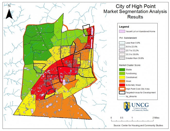
The area has been the subject of numerous revitalization plans since the 1960s; yet, housing and neighborhood conditions continue to deteriorate. The area is overwhelmed by substandard housing, high vacancy rates, empty lots, and affiliated low property values, high poverty rates, low homeownership rates, and high crime rates. As one-third of the total population of High Point lives in this core city area, this rate of vacancy and abandonment negatively impacts a significant portion of High Point residents. Researchers working with the Center for Housing and Community Studies (CHCS) at the University of North Carolina at Greensboro remotely gathered over 15,000 parcel-level assessments as part of a housing market segmentation study of this area. We developed an external assessment tool that employed new GIS applications developed by Loveland Technologies to conduct assessments in nine census tracts.
The remote external assessment tool was used to record the number and condition of parcels indicating if they were occupied, vacant, abandoned, and the condition of structures on the properties. This data was matched with current data from the City of High Point (condemned buildings, crime data, public services data, etc.), and information on community economic, demographic, and social conditions. ArcGIS was used to produce maps showing the Core City overlaid with geospatial data from a variety of national (such as the American Housing Survey) and local jurisdictional sources (such as tax records and crime data). This data was used to then create a geospatial market segmentation index. Market segmentation is a process of analysis that divides an area by natural geographic bounds as well as by demographic, social, economic, political, and cultural divisions. This information allowed for neighborhoods to be ranked as stable markets, functioning markets, constrained markets, weak markets, or extremely weak markets. The study areas in the Core City are some of the most segregated and impoverished neighborhoods in High Point.
Highlights from the study:
- More than half (59%) of units are renter occupied; neighborhoods with the lowest rates of owner‐occupancy are concentrated in the center of the Core City.
- Taxes are delinquent on 7.6%.of parcels.
- Of the total parcels surveyed nearly one‐in-five lots was vacant.
- In the Core City of High Point, 1,425.42 acres total were vacant; the combined tax value of these vacant lots is currently $99,448,500 (excluding publicly owned and non‐taxed land).
- Out of total structures surveyed (n=12,323), 29.1% (3,586) were reported as showing signs of deterioration or damage: 21.7% (2,674) were rated as fair, and 5.2 % (643) were rated as poor.
The analysis was used to match revitalization efforts to neighborhood conditions and provided the City of High Point with a roadmap to redevelopment. This technique may be readily applied to other towns and cities. For example, we are currently conducting a parcel-level census of more than 86,000 parcels in Greensboro, NC. To view the full report and findings please see: http://tinyurl.com/CHCS-HighPointStudy