City of High Point
The Center for Housing and Community Studies is working with the City of High Point on a five-month study that will inform targeted redevelopment in the City Core.
The primary focus of the Market Segmentation Study is the creation of a neighborhood condition index for High Point based on measures of neighborhood stability. Market segmentation study involves a process of evaluation which delineates spatial areas according to implicit geographic bounds and by demographic, social, economic, political, and cultural divisions. Employing established means of market segmentation analysis, the target market is being categorized into two or more groups.
The analysis will rely on data from the individual, parcel and neighborhood levels. Resident-level data such as age, gender, race, educational background and other characteristics allow us to discern categorical groupings within a defined geo-spatial area. Secondly, parcel-level information regarding housing characteristics, including sales volume, price trends, investor purchasing, foreclosures, vacancy and abandonment add another dimension of analysis. Inclusion of neighborhood-level factors such as crime rates, occupant transience, supermarket access, socioeconomic vulnerability, components of social capital and HUD opportunity indices further enhance the detail and scope of market segmentation analysis.
Multiple sources of existing data and reports are being used to provide a foundation for the project. Additional secondary data will be collected with assistance from the IT Department at the City of High Point. Primary data sources include:
- National Sources: The American Housing Survey, Decennial Census, American Community Survey, Home Mortgage Disclosure Act (HMDA), US Postal Service, ESRI data and HUD Tools, among others.
- Local Sources: Guilford County tax records, foreclosures (registrar of deeds), crime data, housing code enforcement data and utility shut-offs, among others.
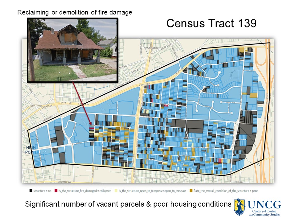
The Center for Housing and Community Studies has also completed primary data collection in the form of a parcel-level housing stock assessment. These data include qualitative visual and quantitative variable assessments of parcel and housing characteristics for more than 15,000 properties located in the Core City target area. In the near future, these assessments will to be conducted across the entirety of High Point and Guilford County.
A sample of selected findings noted in initial analyses reveal that nearly 30% of structures throughout the study area show some measure of deterioration or visible damage. Among these structures, nearly 5% showed evidence of fire damage. Nearly 7% of damaged structures were boarded and secured, yet 2.2% were open to trespass. Overall structural condition ratings reveal that approximately 73% were rated as in “good” condition, 21.7% were rated “fair,” and 5.2% were rated “poor.” Thirty-one properties (0.3%) were extensively damaged and recommended for demolition. Among all properties, approximately 90% appeared to occupied. A little less than 5% clearly appeared to be unoccupied and the remaining 5% showed signs of questionable occupancy.
We are in the process of conducting spatial analyses using these data within a geographic information system (ArcGIS) to provide a housing stock profile for the City of High Point. This analysis will include the creation a five-level typology used to identify and characterize high risk/poor condition areas as well as high opportunity areas, at both neighborhood and sub-neighborhood scales. The market segmentation analysis model employed for this study has been adapted from one implemented by the City of Youngstown, Ohio and is well-suited to the goals of the High Point Core City project. The final report will clearly identify the following neighborhood and sub-neighborhood segments:
- Stable/Strong Neighborhoods
- Functional and Constrained Neighborhoods
- Weak/Very Weak Neighborhoods
A version of the analysis will be made publicly available via ArcGIS Online, including an online parcel-level map of the assessment areas.
For more information about market segmentation, housing stock profiles, and redevelopment studies in your area contact Dr. Stephen J. Sills at [email protected]