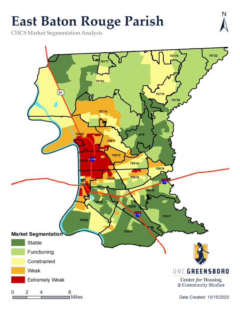
East Baton Rouge Parish
This study was developed by the Center for Housing and Community Studies (CHCS) in response to a request from Build Baton Rouge, the City of Baton Rouge, Healthy BR, and the Mid-City Redevelopment Alliance who are leading the Housing 1st Alliance efforts to solve for affordable housing needs in East Baton Rouge Parish. East Baton Rouge Parish an area with unique needs, strengths, and weaknesses. As noted in the 2019 – 2023 Consolidated Plan & 2019 Annual Action Plan of the City of Baton Rouge and Parish of East Baton Rouge, “Lack of safe, adequate, accessible and affordable housing continues to be the biggest issue facing the Baton Rouge area. The aging housing stock continues to deteriorate, even more so after the 2016 floods, and many hurricanes and tropical storms impacting the area. According to the report, “This has led to substandard housing conditions for many low-income families.”
The project has involved compiling, analyzing, and mapping local jurisdictional, state, and national data sources on residential housing. We have analyzed local mortgage markets, house sales, public housing, voucher programs, market rental patterns, fair housing issues, and other data. A sub-market analysis, or ‘market segmentation model,’ of the Parish has been created from this data. Housing stock and market data, vacancy rates, community condition, health outcomes, and other neighborhood characteristics are all considered in the process.
The project was conducted over a 12-month period. While project team members were unable to visit East Baton Rouge Parish due to COVID19, we met regularly with Baton Rouge Housing FIRST Project Director and members of the advisory committee. We also convened two stakeholder forums and conducted five interviews with key informants. During the process of gathering data and resources from East Baton Rouge Parish we were in contact with service agencies, governmental offices, non-profits, and community leaders. Data collection instruments and protocols were tailored to the local community in an iterative collaborative process.
One of the first steps was to compile and consolidate all existing affordable housing information based on the review and synthesis of existing plans, development codes and other related policies. The UNCG-CHCS project team collected secondary data including federal, state, and local jurisdictional economic, social, demographic, and policy data and reports for the study area. Available jurisdictional data was collected on current housing stock conditions including: zoning GIS layers, code enforcement in the last five years by address, fires by address (last 3-5 years), known boarded secure and condemned properties past 5 years, age of property, and any surveys of property conditions and characteristics. Housing stock data was compiled with market data including Home Mortgage Disclosure Act (HMDA) information linked to Census tracts and block groups. Local new building permits, foreclosures last, and sales data for last 5 years were requested. Locations for current and proposed federal and local assistance properties (LIHTC, Section-8, Public Housing, etc.) were mapped. Known vacant parcels and buildings, demolitions, and fire damaged buildings will be added to the dataset from the EBRP Tolemei system. US Census Bureau Population Estimates, American Community Survey, Census of Population and Housing, Current Population Survey, Small Area Health Insurance Estimates, Small Area Income and Poverty Estimates, CDC health data; State and County Housing Unit Estimates, County Business Patterns, Employment Statistics, Economic Census, Survey of Business Owners, Building Permits, etc. were collected. Data on cost-burdened households was a special focus area, as well as data on vacant properties.
This data was aggregated and combined in ArcGIS and used to create static maps of each data point as well as in computing a market segmentation model of East Baton Rouge Parish including Baton Rouge, Baker, Zachary, Central, and St. George. Target neighborhoods were identified for parcel assessments based on the market segmentation model. We included Delmont Place, Roppolo Villa, Dayton, Midway Place, New Dayton, Istrouma, and Baron Rouge Terrace in the parcel review. The parcel-level housing inventory was conducted using a customized survey developed by CHCS. The inventory covered these selected neighborhoods and was conducted by CHCS staff via remote external assessment. The survey captured structural conditions of the building as assessed from the Google Streetview images.
